Leveraging digital solutions

Isobel Vernon-Avery

Alice Clutterbuck
Globally the pace of change in technology continues to accelerate as breakthrough innovations are continually introduced. Towns offer an opportunity to innovate, trial, and engage communities in some of these technologies and in return, these technologies can enable greater operational efficiencies and improved service provision.
This blog outlines several technologies that are emerging which Towns could leverage. In addition to those technologies below, you can find Towns Fund resources on 5G here.
Internet of Things: Internet of Things (IoT) are a range of different objects that are all connected to each other via the internet, such as air pollution monitoring stations or the smart watch on your wrist. These collect vast amounts of data can be relayed to IoT platforms in order to access data and ultimately improve management of physical assets. IoT can provide benefit to towns through enabling data-driven decision making and enable efficiency savings.
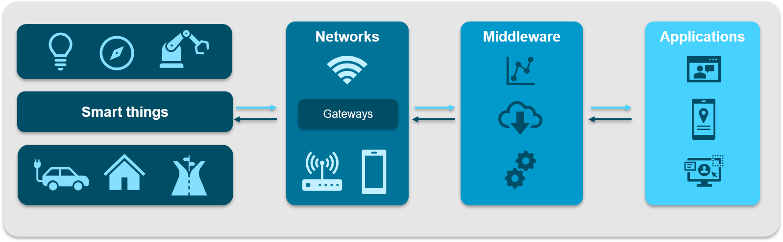
Dublin’s Smart Docklands project has used IoT to address flooding challenges. They developed the Low-Cost Gully Management challenge which is a sensor network that can detect water levels and report flooding incidents using LoRaWAN and Sigfox network technologies. IoT devices can also be deployed in buildings to provide energy monitoring and management.
The city of Zargoza in Spain used IoT and smart building technologies and achieved operational cost savings of 30% within City Hall offices.

Big Data and Analytics: Big Data refers to the large volumes of data generated by digital technologies including mobile phones, websites, satellites, and IoT sensors. This data requires data science or AI tools/methods to capture, manage, and analyse this big data in an efficient way. Big data is often a by-product of our behaviour (see Gartner 2021 trend, Internet of Behaviour), and plays a role in creating an intelligent place.
Towns and cities can process big data to recognise patterns and community needs. Data will require storage and processing – this could include cloud storage, edge computing or hybrid data storage. For example, traffic congestion is a major problem in many urban areas. Transportation can be managed by synthesising data from transport authorities and other sources. The synthesised data can uncover patterns that help reduce traffic congestion and help authorities implement data-driven optimization.

The data pipeline image above shows the process from which data is collected and transformed to deliver insight and subsequently action. Read this link to find out more about the data pipeline process.
Copenhagen Data Exchange is a private/public collaboration to examine private/public data exchanges. This collaboration aims to create a shared data hub to inspire and foster innovation to improve the quality of life, stimulate business activity, and help to achieve carbon neutrality by 2025.
Smart Mobility: Smart mobility refers to the optimised movement of people and goods utilising digital technologies and data. The below video shows how data is integral to creating a smart, sustainable transport system with insight from several organisations including Buckinghamshire City Council who have made transport data open and are trialling e-Scooters.
Remote Sensing Technologies: Remote sensing can be used to observe the Earth from a distance by acquiring data and information from sensors onboard satellites and aircraft. The data captured from space has the potential to help towns by monitoring a variety of assets through time and at large scales, with fewer people needed on site. It can also provide information prior to surveyors or engineers being on the ground, which can lead to better targeting and improved decision making.
The value of remote sensing for towns can been seen in examples such as monitoring land use, tracking urban growth and improving methods for Natural Flood Management (NFM). Remote sensing for NFM employs deep learning techniques to analyse satellite imagery and generate high resolution up-to-date land cover mapping to inform hydrological models and make future recommendations on land cover. This allows towns to monitor how their flood risk changes over time, at large geographic scales and can influence how they plan for the future.
With higher resolution imagery on the rise, smaller scale features can be measured from space too. For example, on the streets, tactile pavement audit capabilities are being developed; an inspection process which would usually require extensive human surveys. Manual surveys are time consuming and require a lot of human effort. So, developing digital tools based around remote sensing can considerably reduce cost and time for towns to undertake investigations.
A large amount of satellite data is open and freely available to download – with all that data accessible the next step is finding new ideas for how it can be used to help our communities.